Biferno Valley Project
The Biferno Valley Project was designed in order to respond to some of the relevant questions concerning the air quality in the Biferno Valley, the lower part of which is one of the most industrialized areas of Central Eastern Italy.
The project was coordinated by the Italian National Agency for New Technologies, Energy and Sustainable Economic Development (ENEA) and Consortium for Industrial Development of Biferno Valley (COSIB) with the participation of several Universities (University of Notre Dame, University of Salento, University of Rome Sapienza, Arizona State University and the Finnish Meteorological Institute).
The area of interest is characterized by complex terrain and land-sea interactions (Fig. 1). The valley is about 2 km wide, about 60-70 km long and flanked on either side by ridges of about 700 m high, which gradually rise to higher altitudes of more than 1000 m. The presence of a coastline as well as the overall terrain morphology suggests that sea breeze regimes and local thermal circulation are prevalent at low synoptic conditions. Given the narrowness of the valley and high gradients, it is expected that pollutants originating in the city to travel long distances along the valley while dispersing vertically due to shear and/or convective turbulence. The local concentrations of pollutants therefore depend on the degree of turbulent mixing, flow patterns as well the variability of the flow. Therefore, understanding of local circulation and turbulence in the valley is crucial to the understanding of the fate of locally emitted pollutants.
Two intensive 10-days field experiments were conducted as a result, which enabled the research group to identify key flow and dispersion patterns as well as seasonal patterns of pollution transport in the area. To this aim, a number of instruments were deployed, including four ultrasonic anemometers, one LIDAR and one Ceilometer CL 31 by Vaisala Inc (Fig.2).
Experiments were conducted in the spring (March-April 2009) and summer (July 2009), and the periods selected allowed study of worst air quality periods from meteorological point of view. The main foci of the field study are:
(i) To map the diurnal cycle of flow and turbulence in representative areas of the valley during the study periods (that covers some seasonality)
(ii) To delineate the role of sea breeze, thermal circulation and synoptic influence on local meteorology and pollutant dispersion
(iii) To identify whether there is a direct correlation between pollutant concentrations and some of the key boundary layer parameters such as the inversion height
(iv) To develop key air quality indicators for the area, so that their measurement or prediction is the bellwether of air quality in the area.
(v) To provide representative dispersion coefficients for the urban canopy layer of the industrial area.
The results of field campaigns show that the complex terrain in the area leads to special types of flows. First, in the absence of synoptic influence, diurnal heating and cooling cycles lead to thermally driven flows consisting of up-valley/slope (anabatic) flows during daytime and down valley/slope (katabatic) flows during night-time. Moreover, transitional flows occur in between different valley and slope flows : (i) the evening transition from up-slope/valley to down-slope/valley flows due to switching of ground heat flux from solar heating to radiational cooling; and (ii) the morning breakup (i.e. morning transition) of night-time down-slope/valley flows to up-slope/valley flows. When the synoptic flow is present, the thermal circulation can be destroyed and the pollution dispersion can be dominated by the synoptic effects, which tends to rapidly disperse the pollutants because of the higher turbulence levels. Other types of forcing also can affect the valley and slope flows. In the context of coastal cities, the presence of a densely built up area within the valley causes an urban heat island (UHI) affecting the wind valley system. Sea breeze that flows landward in the morning and the land breeze that flows toward oceans in the evening are also important in the local circulation (Fig. 3).
In
particular, it was in fact recognised that pressure gradients due to
differential heating and cooling between the ocean, land and urban areas may
cause a rapid morning transition as well as a delayed and prolonged evening transition.
This extended stagnation has implications for evening pollution that builds up
in urban coastal valleys.
The project
has contributed to the existing body of knowledge about the combined influence of
topography, sea and urban settlements on local circulation, understanding of
which is meagre and on which only a few studies exist.
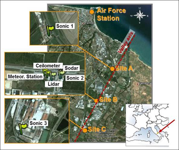
Fig.1 :
Experimental set –up of the field experiments conducted in the lower part of Biferno Valley.
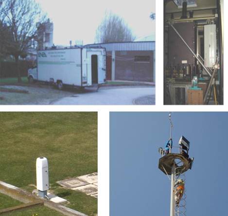
Fig. 2: Details of the instruments deployed in the Biferno Valley: Sapienza” – Rome University Lidar, installed on the vehicle (up panel); Ceilometer by Vaisala (bottom panel on the left); sonic anemometer tower (bottom panel on the right).
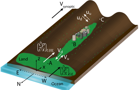
Fig. 3: Schematic representation
of a coastal valley with an urban site at some distance away from the coast