
A Cave of Candles / by Dorothy V. Corson
Chapter 14
A New Discovery -- St. Angela's Island
In the meantime, I made a stop at the St. Mary's Cushwa-Leighton College library to share my latest findings with Bob Hohl, long time reference librarian. As with Peter, he had been an encouraging influence from day one of my search. Before I stored the bulky maps of Notre Dame and St. Mary's away for safekeeping I wanted him to see them.
For an hour we poured over the maps pinpointing different areas of interest, looking for new insights. I showed him a copy of the 1880 Class Day Book, which led to the former location of the St. Mary's Grotto. In sharing my recent research with him, a casual comment he made unwittingly sent me on another interesting side path associated with Our Lady.
I had just pointed out, on the 1878 map, a place in the glen labeled as a pond which I knew was not there now. It must have triggered something in his memory, because he said, "You know, I've often wondered about something I've read in Eugene O'Neill's play Long Day's Journey Into Night.(159) The author speaks of his mother and the girl's school she attended in the Midwest. Others who have read it, felt it might have been St. Mary's. An island is also mentioned in connection with the school. I've never tried to check it out, but I've wondered about it."
As we parted company, he thanked me for taking the time to show him the St. Mary's campus and its buildings as they looked in 1878. Having shared my finds with him almost from the beginning of my search, we both had now acquired a keen interest in these little mysteries that seemed to be willing me to record them.
He checked out a couple books on the history of St. Mary's for me, urging me "to continue with my search and then write it down for others to read. And let me know," he said, "if you find any information about an island associated with the St. Mary's campus." I was blissfully unaware that another unplanned archival adventure awaited me, this time, an interesting island mystery to solve.
I was pouring over the history books Bob had located for me looking for more data about the early St. Mary's Grotto, when I stumbled upon something else of equal interest -- information about the island Bob was curious about. Without realizing it, in following his suggestion, I was being led to another item of history associated with Our Lady, Notre Dame and St. Mary's.
On the copy of the small 1878 St. Joseph County map, there was a numbered listing of all the buildings on both campuses. For the first time, I looked at the whole list rather than just those areas I was directly interested in. On it, I found a reference to a St. Angela's Island and wondered how I'd missed it. There it was in the St. Joseph River, barely visible without a magnifying glass, a short distance off the shoreline of St. Mary's College campus. A road seemed to lead to it. I wondered how large it had been and whether there had been a causeway to it or if it was fordable.
A phone call to Bob supplied additional information. Pleased to find this link to the O'Neill novel he said, "You know, it's beginning to make sense" and he repeated what he knew of the area that might have been where the island had once been. He said it was his understanding that Pinhook Park across the River and a little north of the St. Mary's property, had once been a part of the St. Joseph River. That there had been a large loop in the river in that area. It had presented a problem for river navigation in the 1920s and a decision was made to fill in the mouth of the loop making it a lagoon to straighten the path of the river and make room for what is now Riverside Drive.
St. Mary's undoubtedly would have had to give their permission, since the island might be flooded by the redirection. It seemed reasonable to assume that perhaps it was flooded and no longer existed. The 1878 map pretty much verified his assumptions. I left it at that not thinking too much more about it until I found the following very interesting 1879 reference to that long forgotten oasis in the St. Joseph River:
This lovely island like an emerald gem in the bosom of the placid St. Joseph is a favorite place of recreation for the pupils and is popular among the young ladies as a resort for fishing and summer picnics.(160)
Pleased that another bit of history had been verified, I did not suspect that I would also find, in the history books Bob had suggested to me, this lovely quote regarding Our Lady and the island's earliest days:
The summer of 1857 filled the community's cup of joy to the brim. It brought a visit from Father Moreau from France. Long had the father founder desired to see the fruit of his children's labors in foreign lands. It was twenty years since he had founded his congregation . . . .
Business did not exclude pleasure, however, as an account of the blessing of Saint Angela's Island clearly shows. It was the feast of Our Lady's Nativity.
In an earlier book, On the King's Highway, Sr. M. Eleanore, C.S.C., records Mother M. Elizabeth's detailed description of the elaborate ceremony she witnessed:
By way of preparation Mother M. Angela borrowed from town several bolts of muslin for decorative purposes. Joseph and a few other men hired for the day hauled brushwood to make bonfires at short distances apart on the way to the island. Under a large tree on the island they erected an altar, which the Sisters decorated with candles and wildflowers. On a wire between the trees in front of the altar they hung a large lamp frame made of white down and feathers. On the trees along the path leading to the altar they put small tin holders for candles and nailed pictures under them. The bridge was draped in muslin and was lit by colored lamps.
In the afternoon the Sister sacristan at Notre Dame sent over to the Academy parlor the surplices of the priests. There was an early supper, after which all the Sisters from St. Mary's and from Notre Dame formed in procession with lighted candles. At seven o'clock Father Rector and the clergy, having been invited to what they supposed was a little entertainment, came from Notre Dame, took chairs, placed them in front of the Academy, and began to smoke and enjoy themselves in the company of Mother M. Angela and her Council. When the bell rang, Mother invited the clergy into the parlor and asked them to put on their surplices. They were somewhat surprised until Mother told them that the Sisters wished to have Father Rector bless the island. At her request the clergy took ranks. She then opened the back door of the Academy to disclose to their astonished gaze the illuminated path, which seemed a fairyland of light. Father Moreau stood as if entranced.
The long procession filed down through the woods, singing as they went. In half an hour they reached the rustic bridge, where the Sisters halted in ranks through which the clergy passed. Father Moreau blessed the island, giving it the name of St. Angela. Father Sorin and Father Sheil, Provincial of New Orleans, were his assistants. After the blessing Father Rector spoke to us in French, which Father Sheil translated for us. Father Moreau expressed his extreme pleasure over finding in the woods of far-off Indiana such great love for the Mother of God and promised that he would never forget the heavenly scene he witnessed that evening on ground consecrated to Mary Immaculate. He said he had much to say, but the American night birds sang so loud he could not make himself heard. These night birds were the katy-dids and the tree frogs who were shouting their protest against this invasion of light and human sound into their own domain. No matter what katy did or didn't do on other occasions, on that night, at least, she out-talked a whole religious Community. Some few persons complained to Father Moreau because Mother M. Angela burned so many candles; but he reminded them of a certain box of ointment once poured on the Master's feet.(161)
Intrigued by this unexpected find, I decided to continue my focus on St. Mary's history until the University Archives reopened. It was time well spent. In two other books,(162) I found two pictures of what appeared to be the St. Angela's Island. One, viewed with a magnifying class, looked like the remains of the bridge in two parts, a piece hanging from the main land and one from the island. A group of Sisters appeared to be looking toward the island from the bank of the mainland.
I obtained from our local library, a script for Eugene O'Neill's, Long Day's Journey Into Night, and proceeded to look for the references to St. Mary's in it. Being autobiographical, I understood it to be about his mother and her going to a convent in the Midwest. It did not give the name of the school. However, throughout the whole script there were a number of one or two line mentions of a convent in at least ten different places. The last and most lengthy references were on the last page of the script, which I will detail, in part, below:
I told Mother Elizabeth I wanted to be a nun. I explained how sure I was of my vocation, that I had prayed to the Blessed Virgin to make me sure, and to find me worthy. I told Mother I had had a true vision when I was praying in the shrine of Our Lady of Lourdes, on the little island in the lake [river]. I said I knew, as surely as I knew I was kneeling there, that the Blessed Virgin had smiled and blessed me with her consent. But Mother Elizabeth told me I must be more sure than that, even, that I must prove it wasn't simply my imagination . . . . I never dreamed Holy Mother would give me such advice! After I left her, I felt all mixed up, so I went to the shrine and prayed to the Blessed Virgin and found peace again because I knew she heard my prayer and would always love me and see no harm ever came to me so long as I never lost my faith in her. . . . That was the winter of my senior year. Then in the spring something happened to me. Yes, I remember. I fell in love with James Tyrone . . . .(163)
What I hadn't expected was yet another connection to the University. Eugene O'Neill's mother, Ellen Quinlan, graduated from St. Mary's and his father, James O'Neill, graduated from Notre Dame. Edward Fischer, in his book, quotes Marion McCandless on this famous couple:
As a married couple they later traveled up and down the land together. James O'Neill was one of the great tragedians of his day. His Monte Cristo will always remain a classic of the American stage. But the greatest contribution the O'Neills made to the theater was to give it their son, Eugene, the famous playwright.(164)
The several mentions of the St. Angela's island, most especially the candlelight procession, prompted me to search for maps of the St. Joseph River to see if I could locate the island if there was anything left of it. It had been one hundred and thirty-six years since its dedication by Father Moreau. A call to the County-City Building to the surveyor and several other offices proved of little help.
The next day, I found another interesting item, browsing through the index of an Ave Maria, a poem entitled "Island Cemetery." This time it was a reference to the "island" in the lake at Notre Dame. It was a beautiful little poem written in 1856, very descriptive of the Notre Dame campus in its very early days. At the top of the poem was a note about the then island cemetery in the St. Mary's Lake at Notre Dame:
. . . About the year 1868 the bodies then resting in the 'Island Cemetery' were removed to the present grave-yard on the grounds near the Scholasticate.(165)
This brought to mind the Golden Jubilee article, mentioned earlier, and its description of the original "one lake" with its island. An island large enough to have a cemetery even before the lakes were lowered. It was the first evidence I had seen of an earlier cemetery on the island.
The story behind the chapel on Notre Dame's "island" is an interesting one. The first winter after the Sisters had arrived from France was a severe one. Sister Mary of Calvary(166) fell ill and was pronounced near death, to the great distress of all. Sorin promised if she lived a chapel would be built on the island in the middle of St. Mary's Lake. She recovered and he did build a chapel in the spring of 1844. It was called "Most Holy Immaculate Heart of Mary." Sister Mary of Calvary had the honor of laying the first stone.
Once the lake was lowered, the marshes filled and the island enlarged the old cemetery must have been in an inconvenient place and the bodies were moved to the present community cemetery to provide more room to build the new buildings. Bro Vitus had told me earlier that the smaller islands in the lakes were all man-made from the overflow of dirt dug out for the cemetery road.
While going over this new evidence in my mind, I recalled the help given to me by the St. Joseph County Archivist at the County-City Building the previous summer. We had discussed this question of one or two lakes and it occurred to me he might be interested in this "Island Cemetery" poem since his own special interest was of that early period.
I had already reached a stalemate at the County-City Building in trying to find anything more about the St. Angela's Island in the St. Joseph River. I decided to give him a call and pass on the "Island Cemetery" poem to him in return for the help he had previously given me.
Jackson Armstrong Ingram had not seen the poem and was pleased to have a copy. He asked me how my research was progressing. When I mentioned my stalemate in finding the present location of St. Angela's Island at St. Mary's, if it still existed, he said he was sure he'd run across an old 1859 book in the stacks at the Hesburgh Library that referred to St. Angela's Island. He gave me the call numbers of the book and suggested I look in the plat books in the auditors office for the island's present location. My impromptu visit had supplied additional information on St. Angela's Island and another clue to follow.
Another Trip to the County-City Building
On my second trip to the County-City Building, the same man helped me who had been so accommodating the year before. He said it might take him a while to locate that specific area of the river opposite the St. Mary's campus, and while he was looking for it, I might want to check the Area Planning Commission office on the 13th floor to see if they might have other maps. Their aerial views of that area only went back to 1966. However, when the film was viewed on a back-lighted drawing board, it indicated a small island in approximately the same spot as my 1878 map had shown it.
On an 1893 plat book at the St. Joseph County Library, it seemed to be much larger. Time and erosion, I was told, would have accounted for a change in size as it was not uncommon for an island to appear and disappear over time. From his measurements he judged the island in 1966 to be about 60 feet by 150 feet and there was evidence there was also a large tree on it at that time. I had my proof! For a $5 charge, I was able to obtain a 24" square blueprint copy of the 1966 aerial view of the campus worth framing to pass on to the St. Mary's College archives.
Shortly thereafter, from the call numbers the county archivist gave me, I located the 1859 Guide To South Bend, Notre Dame du Lac and St. Mary's Academy in the Notre Dame Library stacks. Written across the top of it was the penned signature of Master Thomas Ewing, an early student at Notre Dame. Inside, was an earlier, 1859 description, of St. Angela's Island, confirming what I had already detailed from other sources. In addition, it also described two other items of interest. It spoke of St. Mary's Academy:
being situated most charmingly on the high bank overlooking the St. Joseph, which seems tenderly to encircle its loved charge. These waters among other peculiarities, possess the strange one of never freezing over in the coldest weather.
I hadn't been aware of that aspect of the St. Joseph River, although, I had come across evidence that the Indians called the St. Joseph River the mystery river because it flowed upstream, or backwards, as the Nile River is said to do in Egypt.
The Guide book went on with this next charming description and another clue to follow:
The gate of the Academy is attended by a lone Indian, one of the few remaining in the region. His cottage stands before you as a porter's lodge on the public road. Kindness and charity bestowed this situation, when old age and infirmity were upon him.(167)
Armed with the guide book and a copy of the aerial photograph, I shared this additional information with the St. Mary's College Archives and my reference librarian friend, Bob Hohl. Another bit of St. Mary's campus lore had been verified. Now Notre Dame and St. Mary's both had an island. Sister Rosaleen, St. Mary's College Archivist, confirmed its probable location. She said she had been hiking in that area about eight years ago and waded over to a sandbar in the river. She hadn't known it then, but hearing my story, thought it might be what was left of the island.
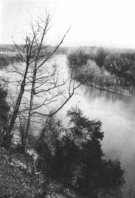
Several weeks later, after several unsuccessful attempts, I found the island from the other side of the river hidden from view by a stretch of woods directly opposite it. In following a path in the woods, I passed a small open spot with a sandy shoreline which revealed, finally, the island on the other side. As Sister Rosaleen had described it, it seemed to be mostly a sandbar now, but one large dead tree gave evidence it truly was all that was left of that "emerald gem in the bosom of the placid St. Joseph River."
Yet another passage from a convent history book was further confirmation of Sorin's closeness to St. Mary's and the Sisters of the Holy Cross. It related how Mexican ponies were bought for the Sisters by Sorin for the student recreation. The Scholastic describes them:
The arrival of those long expected Mexican ponies has created quite a sensation in juvenile circles at St. Mary's. The Juniors and Minims are everlastingly grateful to Very Rev. Father General, for his generous kindness in furnishing them with such an agreeable means of enjoying themselves. Each pony will no doubt prove a pleasant hobby which the Juniors and Minims may safely ride, for at present "Ponies" seem to be the topic of interest, even beyond the promised sleigh ride which is to recreate the pupils after the fatigues of examination.(168)
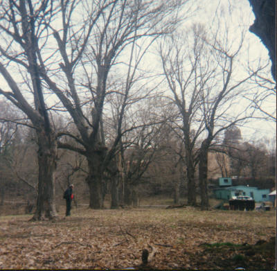
Unfortunately, the Sister recorded, they turned out to be too mean to use for that purpose. Over the summer holiday, the Sisters tried to break the ponies but were not able to and they had to be replaced. An avenue of trees above the 1937 grotto in the glen could easily have lined a secluded carriage lane or bridal path leading to the island. The meadow is now overgrown except for the ancient trees marching toward the river.
The Scholastic describes the glen and the island as it appeared in 1879:
The laundry below the bluff and on the bank of the river is to be removed and recreation grounds extended to the water's edge. These rugged bluffs are the most picturesque points about Saint Mary's. They are thickly covered with a growth of forest trees, massive rocks crop out here and there and when paths are made down to the gravely bed of the river, little will be left undone to make it one of the most sought after retreats in all the grounds. Right at these bluffs the river makes a sudden bend in a westerly direction, leaving many acres of bottom land, which have been turned into a large and fruitful orchard. Near this beautiful island, which is connected to St. Mary's main-land by a bridge, many of the pupils are allowed to go and fish on stated occasions. At the edge of the bluffs and on a level with the Juniors recreation grounds are two or three summerhouses for their use. Near theses are immense grape arbors which run northward an interminable distance and afford a bountiful supply of this delicious fruit for the academy(169)
One could only imagine what the glen looked like in its early days when there were landscaped paths, river walks and flowering shrubs and trees in profusion. Father Boehm has described the glen, now a wilderness, as a riot of color in the springtime, carpeted with violets and myrtle, daffodils and crocuses, and countless other colorful perennials, planted ages ago. Fragrant lilacs and bright forsythia dot the now wild landscape.
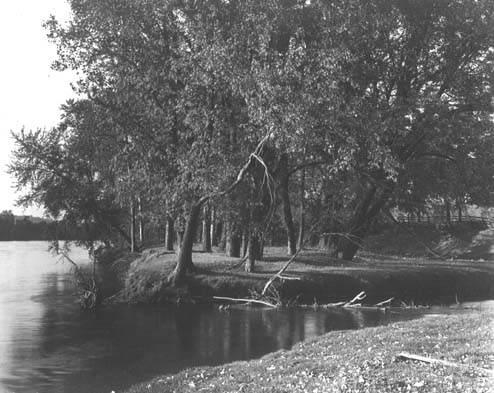
As I was concluding the St. Mary's portion of my research in preparation for my return to the University Archives, I received a call from Sister Rosaleen at the St. Mary's College Archives. She happily informed me that she and a student helper had been going through storage boxes of old photographs in an effort to date them and identify the people in them. They had come across a very good matted 8 1/2 x 11" photograph labeled "St. Angela's Island" and she had a copy of it waiting for me anytime I wanted to pick it up. At last, no more doubts about it, there it was as clear as any photograph could make it. It is the photograph at the head of this chapter.
Having seen and photographed what appeared to be the island from the other side of the river during the winter months, I decided to delay viewing it from the glen until better weather. It was readily apparent from a glance at the glen from the bluff above that my return visit would have to be postponed until early spring or fall. The density of the undergrowth during the summer months would make exploring the area at that time almost impossible. I put my plans on hold and concentrated on pursuing other portions of my research while I awaited with anticipation a return to the glen.
The avenue of trees, especially, intrigued me. It seemed to say, follow me. I would not have noticed them at all had I not taken time to document my first visit to the Grotto in the Glen with photographs. Because the location of the remains of the Grotto was hidden in the undergrowth, and difficult to find, I put my back to the Grotto and took a picture facing toward the buildings on the bluff above the glen using a turquoise maintenance building as a landmark. When the film was developed, it revealed in the photograph an obvious avenue of trees, otherwise not apparent to the eye. I wondered about it at the time but this was long before I'd heard of the island or seen the 1878 map showing a lane leading to it. I looked forward to the day I would be able to view the glen up close, to see for myself, if this avenue of trees might have bordered that long unused lane.
Locating St. Angela's Island From the Glen
When that eagerly awaited day arrived it was early spring. Once again, I approached with anticipation, the narrow winding road leading down into the glen, wondering what I would find left of this once lovely island.
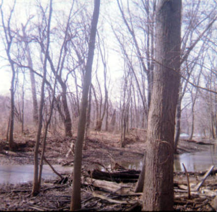
My husband and I picked our way through the brush and brambles past a huge uprooted tree. Its upended root base dwarfed my five and a half feet height. A short distance further we spotted water ahead of us. The riverbank was closer than I'd expected, possibly 200 feet beyond the abandoned Grotto. Eight to ten feet of water washed sand separated the mainland from what appeared to be nothing but an almost barren sandbar with six foot high brush densely covering it, probably the one Sister Rosaleen had mentioned. Its size was difficult to gage because of the wooded mainland obscuring it. I took a couple photographs as best I could and turned to find my way back.
Then I remembered the old tree I'd seen from across the river which was barely visible on the 1966 planning commission map. It was not on the sandbar. I decided to follow the riverbank to the north end of the sandbar just to be sure. As I did so, I stumbled upon the island, just as it was pictured in the St. Angela's Island photograph Sister Rosaleen had given me. The sandbar and small island were so close that it appeared it might have once been attached to the larger sandbar, possibly under water, at one time.
The small island was wooded, just as it was in Sister Rosaleen's undated photograph. There were a few medium sized trees and a span of water of perhaps 8 feet which would have required the footbridge noted on the 1878 map. One larger standing tree, that appeared to be dead, must have been the one I had seen from the other side of the river the winter before. The description of Moreau blessing the island had mentioned the Shrine of Our Lady being near a large tree, perhaps this was the same one.
I took several photographs of it and turned to leave when I noticed a profusion of crocuses and other plants sprouting up all around me on a slight incline facing the island. Seeing them, I remembered a reference to the Sisters pinning up their veils and skirts when they worked in the glen. I was picturing them in my mind planting the bulbs as I maneuvered my way around them and took another photograph of it at the top of the incline which hid the island from view from that direction. As I turned my back to the island area, I looked around to get my bearings, before retracing my steps out of the glen. When I looked up there was the avenue of trees revealed in my earlier photograph. They led directly to the island. Mission accomplished I'd solved another mystery.
Not only the Grotto in the glen had been located but also evidence of all that remained of what must have once been, a lovely little island oasis, on the St. Mary's side of the St. Joseph River. I could only imagine, now, how the glen and the island must have echoed with young voices and high spirited activity in days gone by. In the 1890s, the river bank had twice been retained with a stone wall to protect the shoreline. Pictures(170) as late as 1905, such as the photograph at the head of Chapter 13a, show cows being pastured nearby.
In a later conversation with Father Carey, a casual comment about the glen and the island at St. Mary's brought forth yet another memory of those olden days. He called the glen at St. Mary's Perley's glen. When I asked why, he said he thought its name came from an early family named Perley who once owned the property (there is still a Perley School in South Bend). He told me they used to go to the glen as young seminarians to avoid the crowds on campus during football games. His next words painted another picture in my mind of those early days, this time of male voices echoing through the glen. He said they used to swing from the grapevines over the St. Joseph River. Considering the reputed swift current in the St. Joseph River it must have been a perilous sport.
I very soon found out what that pasture was used for now. One day I was taking a break in the "Pit," the Notre Dame Library basement lunchroom, with Alice Osberger, a new campus friend I'd met by chance while researching. Alice is the secretary to Dr. Ralph McInerny, the creator of the Father Dowling Mysteries. When I learned she was a St. Mary's Alumna, I told her about my trip into the glen to locate the island.
The next time I saw her she told me she was intrigued by my story and she and her husband also went hunting for it in the glen, one balmy Sunday afternoon. They said the water was low when they were there and they were able find a place to wade across to the island. Whereas when I was there earlier that would not have been possible. To their surprise, she said, they found a number of golf balls on it. Which could only mean that someone was now using the normally deserted nearby pasture area for golf practice and had left his evidence behind.
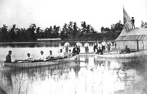
In paging through an 1873 Scholastic about this same time I also found an interesting article entitled: "A'Hoy! on the St. Joe."(171) It described Notre Dame students, teachers and priests embarking from St. Angela's Island on "the often contemplated trip down the St. Joseph River to Niles on July 4, 1873:
These our three good and fair galleys, [Notre Dame's early racing boats] the Santa Maria, the Pinta and the Nina darted from the northern point of St. Angela's Island at 10 a.m. They were manned by the merriest crew that ever beheld the swift St. Joseph. The boats were to keep fifty yards apart following one another; the little Nina, with Fathers Lemonnier, Carrier, Zahm and Berdel in the van; the Santa Maria following carrying seven aboard, Prof. Stace, coxswain, and the Pinta with seven more aboard, nobly bring up the rear (which she never did before).
The account describes the river as it was in 1873:
Only a few rods from the point of embarkation, a huge boulder firmly driven in the swiftest part of the current suggested momentary fears of ill omen for the rest of the voyage. The Nina swung around it in approved style and in this was skillfully imitated by her two followers. The Dutch Gap, famous in Scholastic lore, was the next distressing peril. The St. Joseph took, once upon a time, into its head to change its bed, and regardless of the property of Mr. Von Dickenhausen, took a short cut across his field which it divided unequally into two parts, making him at the same time the sole undisputed proprietor of an Island. Well the new channel had been cursed by the evil-eyed Von Dickenhausen, so the legend says, and many a reckless adventurer had risked his life in its angry current. The old trees snatched from the stolen field blocked and obstructed the navigator's path, in a manner that made the boldest heart quiver with fear. The Nina, with the priests aboard, slackened speed and bade her followers to be on the watch and put on the brakes also. The peril, as it drew nearer, like fabled tales, grew less; and bolder grew the hearts of the shirking galleys. Little Nina with prow well directed and vigorous dash from the oar, nimbly jumped over the abyss and its whirlpool and in an instant more swam far beyond, just in good sight of her followers which followed her lucky track with the same dexterity and luck.
The river is described as they go along, the old Mill and its rosy looking and talkative miller (where Isaac Walton is now), "the cottages of Bertrand and its venerable old-fashioned bridge, the little church of the earlier St. Mary's Academy, a city once famous and thickly populated, now alas, reduced to a mere name." After several landings to view the beautiful groves on the shore of the river, the Niles dam is sighted and portaged and Niles is reached:
The best speed was now made, all the oars were lustily plied -- the wooded bridge was cleared in a twinkling, then the iron bridge. At last the landing was reached, and the travelers got for the last time on terra firma. Half an hour later the boats were placed on board a car of the M. C., and at 5 1/2 P.M. all were back at Notre Dame.
Two years later, the October 1875 Scholastic, reported the fate of the noble Pinta. "The Pinta now sleeps the sleep of peace on the bottom of the lake. She preferred death to defeat -- and she got it."(172) From what I have learned she must have had lots of company there among the many other items discarded in the lake.
Visualizing the activity in the glen and on the island in those days, and the river walks along the shoreline of the St. Joseph, I could not help but wonder why this lovely natural oasis on campus -- this fun-filled place of quiet reflection -- had been left untended and abandoned. I could only surmise that it had somehow outlived its usefulness. It was yet another mystery that seemed beyond solving.