Erosional Landforms
Streams in arid regions are different from
those in humid climates.
Most streams are intermittent and many have braided channels.
Deep canyons in dry climates usually have
near-vertical walls and box-like profiles.
Where rivers traverse and cut horizontal
layers, cliff-and-bench topography develops. More resistant
layers = steep slopes; weaker = gentle slopes (e.g., Colorado Plateau).
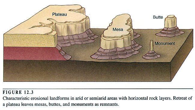
Plateaus: comparatively
flat upland areas formed in regions of horizontal rock layers. The plateau
becomes dissected by rivers and distinctive landforms are produced.
Mesa: a generally
flat-topped area, bounded by cliffs, that is quite a bit wider (usually) than
it is high.
Buttes: smaller,
flat-topped landforms isolated by erosion. They are more or less as
wide as they are high.
Monuments (or spires):
slender features that are much higher than they are wide.
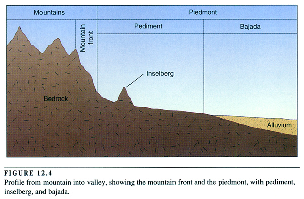
Where the bedrock is not horizontal, rugged
mountain ranges are separated by valleys with flat floors. In the Basin and
Range province of the western USA, mountains are uplift along faults.
A sharp break in slope marks the mountain front.
Piedmont:
the gentle valleyward slope from the mountain front.
It consists of the bajada and the pediment.
Bajada:
formed by deposition.
Pediment:
gently sloping erosional surface that cuts across
bedrock, and typically has a thin veneer of sediment on its surface. It is
thought that the pediment develops as the mountain front retreats.
Inselbergs:
erosional remnants that form isolated hills on the
pediment.