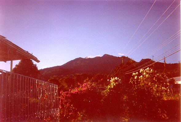
Volcan Baru looms large over the village of Cerro Peunta.
Volcan Baru looms large over the village of Cerro Peunta.
Volcan Baru is a dormant volcano located in the Chiriqui province of Panama. It is roughly equidistant from Panama's northern and southern coastlines, and about 25 kilometers east of the border with Costa Rica.
The mountain's main distinction is that from its summit, on a clear day, it's possible to see both the Atlantic and Pacific oceans (or, to be more precise, the Caribbeen and the Pacific). This highlights just how narrow the Central American isthmus really is. It was a quest to see the two oceans simultaneously that drove me to climb Volcan Baru in the spring of 2000, during a week long trip to Panama.
It's hard to get good information about Volcan Baru. What's on the web is sketchy and contradictory, and the Lonely Planet description isn't much better. So the first order of business before undertaking the walk was to procure a good map of the Chiriqui area. This was achieved by a visit to "Tommy Guardia" in Panama City, the home of Panama's Geographic Institute, and the only place where 1:50,000 maps of the country are available. At Tommy Guardia, we were required to give our names and US addresses before being allowed to buy the maps we needed. It was not at all clear why.
We traveled from Panama City to Cerro Peunta, a beautiful village nestled into the western slopes of Volcan Baru. On out first night there, we spread out our maps on the table of our digs; the landlady told us that the only other time she had seen such detailed maps, they were being used by geurillas during the civil war!
(Next two pictures courtesy of Laura Randell)
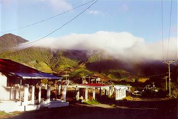
The beautiful village of Cerro Peunta (Photo by Laura Manninen)
From the maps, it was not obvious how we would make our way up to the summit. But the next day, while hiking the stunning Sendero Los Quetzales, we met up with some locals who offered to guide us up the mountain the next morning, for a small (large) fee. The deal was struck, and Cliff and I agreed to meet with our guides at 7am the next morning, outside our digs.
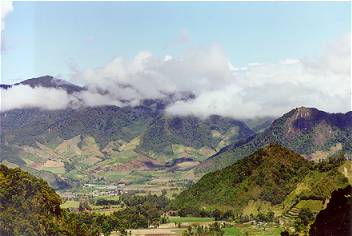
The Cerro Peunto valley, from Sendero Los Quetzales (on the northern slopes of Volcan Baru) (Photo by Laura again)
7am came and went, and the layabouts to whom we had offered the better part of a week's wages to never showed up for their day's work. We were livid; but perhaps it was a good thing. The weather that day was poor, with a low cloudbase and a swirling mist.
So we made our way to Boquette, the large town on the eastern side of Volcan Baru. From there, the map seemed to indicate that there was a road leading all the way up to the summit. (Just below the summit, there is an important microwave telecommunications station; the road was build to provide access to this.)
We were staying in a small hotel in the center of Boquette. When we told the proprietor of the hotel that we were heading up to Volcan Baru, he set us up with his friend (probably boss) Mark, who agreed to drive us (again, for a small (large) consideration) to the point where the paved road ended and the dirt road began. He wanted to start at 7am, but we negotiated him down to 5.30am.
So the next morning, dark and early, we hopped onto the back of Mark's 4x4, and set off. Reaching the dirt road, we kindly declined the joint proffered us by Mark, and, still in the darkness, began to ascend the long and winding dirt road to the summit.
As dawn broke, the climb, which until then had been strangely peaceful, became dull, and hard. Every so often, we would see the microwave towers in front of us, and convince ourselves that we were almost there; but we never were. And the higher up we went, the slower we seemed to be moving. Then the solution to our woes finally dawned on us - we became realistic. The next time we saw the towers off in front, we agreed that we had probably an hour and a half, maybe two, to go to reach them, and that from there, it might be another 100 meters ascent to the summit. And of course, ten minutes later we were trotting right past the towers, and clambering up the final vertical twenty meters to the summit!
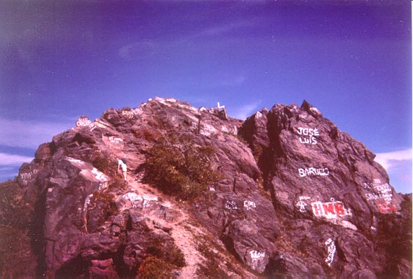
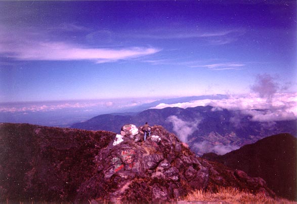
Cliff makes his way up the final few meters. The graffiti suggests that this is a well visited peak!
Like Carrauntoohil, Ireland's highest peak, the summit of Volcan Baru is marked with a cross.
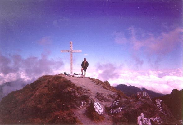
David at the summit (Photo by Cliff Smyth)
We had set off at 5.30am in an effort to reach the peak just after dawn; it's only then that it's potentially possible to see the two oceans. I think, 'though, that we were out of luck. Although the visibility was good for the first half hour or so that we were at the peak, it was probably just a little bit too hazy to be able to clearly make out where land ended an sea/sky began, in both directions.
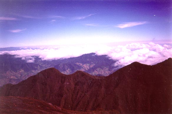
The view north, towards the Atlantic
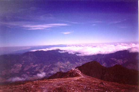
The view south, towards the Pacific
Nonetheless, we felt well pleased with ourselves for what we had achieved. We took a well-earned rest at the summit, just admiring the beautiful expanse of Panama below us, then we clambered about a bit on the summit rocks, and even managed to locate (and go a little bit down) the elusive Cerro Peunto trail. But after about an hour on the summit, the clouds began to seriously roll in, so we headed down.
Cliff heads west towards Costa Rica (but probably won't make it; there 25k of jungle to cross first!)
The descent was a nightmare - steep and rocky, a devil on the knees. By the time we reached to point where Mark had left us off that morning, we were seriously out of patience. The thought of an eight mile trek along the paved road into Boquette was not pleasing. Fortunately, we were able to flag a ride for most of the way.
Footnote: A few days later, we took a 'plane ride across Panama; and at one point during the ride, we were very clearly able to see the Pacific out of one side, and the Atlantic out of the other. So, in some sense, I was successful in my quest!
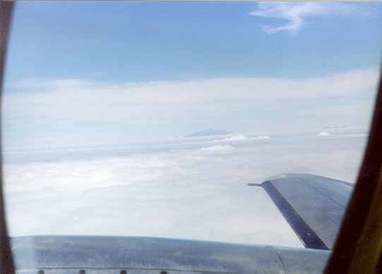
The Summit of Volcan Baru pokes out from under the clouds; David Radnell took the picture as we flew across the country a few days later.
Back to my personal page.